Planning new woodland - Appendices
Updated 10 December 2024
Applies to England
These appendices relate to the planning new woodland in England guide.
Appendix 1: producing maps
Producing maps and plans for your woodland creation proposal
This appendix provides advice on general mapping standards for woodland creation proposals, and what to show on the maps and plans in your woodland creation plan (including examples).
General mapping standards
When assessing a woodland creation proposal for an Environmental Impact Assessment (EIA) decision or a grant funding application, the Forestry Commission expects certain general standards to be met by the maps that you submit.
Backdrop
Your maps must be based on up-to-date Ordnance Survey mapping (or mapping of a similar standard and detail). Your site appraisal plan should be produced on an aerial photograph backdrop. Ensure you have appropriate copyright permission where applicable.
Scale
Ensure maps are at a scale appropriate for the detail being shown, and that they have contours clearly marked and at appropriate intervals to illustrate the terrain. A scale of 1:5,000 to 1:10,000 should be used for most of your maps and plans.
Legend and labels
Ensure maps show the:
- name of the EIA or grant funding application
- scale
- north sign
- central grid reference and legend
These markers clearly identify what your maps are showing, and that they are consistent with your application.
Presentation
Proposal details and operations should be clearly and accurately shown, and not obscured by any folds, marks or labels on the map. If you have access to digital mapping software enabling you to produce maps to the required standard, then you can submit maps in either .pdf or .jpeg format.
What to show on your maps and plans
Landscape context plan:
This map shows the location and boundary of the proposed woodland creation site on a colour Ordnance Survey backdrop, with annotations highlighting important features and characteristics of the site and wider landscape context that will be relevant to the planning and design process. Scale: 1:15,000, to include contours. Some topographical data is available free of charge from the Ordnance Survey (you must check any conditions around copyright and data use). See the example landscape context plan.
Site appraisal plan:
This is an annotated spatial plan, zoned according to different landscape types, showing an evaluation of the survey information and key features present on site, ideally on an aerial photograph backdrop. Scale: 1:10,000, or smaller scale if required to illustrate detail sufficiently. It may be useful for larger sites to produce a site appraisal master plan at a larger scale, and zoomed in appraisal plans of portions of the site, where more detail is required, at a smaller scale. See example site appraisal plan (upland) and example site appraisal plan (lowland).
Design concept plan:
This is an annotated spatial plan showing one option for the design of the woodland, shaped by the findings of the site appraisal plan, and is a tool to support consultation processes. You should consider producing more than one design concept plan to show alternative design options. Scale: 1:10,000 to 1:5,000 (or smaller, if necessary), making sure that sufficient detail can be illustrated. Again, it may be useful to produce a design concept master plan with accompanying smaller scale plans showing portions of the site in more detail. See example design concept plan A and example design concept plan B.
Final woodland creation design plan:
The graphic part of your final woodland creation design plan is an annotated spatial plan showing the chosen design concept, finalised following stakeholder engagement, with specific detail added (for example around species mix, planting density, open ground, access points, routes and transitions between woodland open ground).
Map examples
Example site 1: upland
Landscape context plan
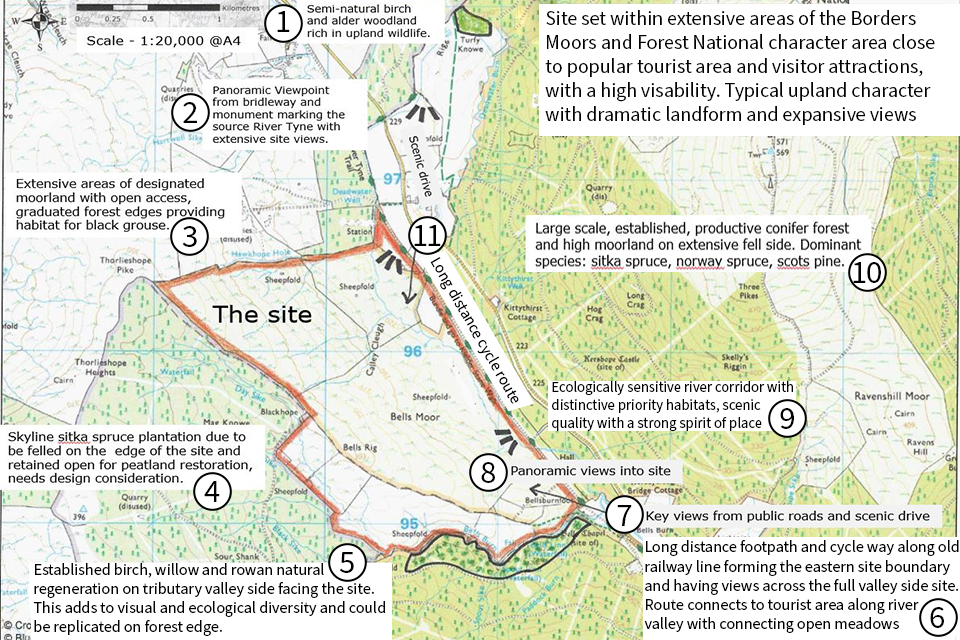
Map 1: annotated map showing main site area. Surrounding areas have been marked with short descriptions. Areas are labelled 1 to 11.
Site set within extensive areas of the Borders Moors and forest National Character Area close to popular tourist area and visitor attractions, with a high visibility. Typical upland character with dramatic landform and expansive views.
Map 1 area descriptions
Area 1: semi-natural birch and alder woodland rich in upland wildlife.
Area 2: panoramic viewpoint from bridleway and monument marking the source River Tyne with extensive site views.
Area 3: extensive areas of designated moorland with open access, graduated forest edges providing habitat for black grouse.
Area 4: skyline sitka spruce plantation due to be felled on the edge of the site and retained open for peatland restoration, needs design consideration.
Area 5: established birch, willow and rowan natural regeneration on tributary valley side facing the site. This adds to visual and ecological diversity and could be replicated on forest edge.
Area 6: long distance footpath and cycle way along old railway line forming the eastern site boundary and having views across the full valley side site. Route connects to tourist area along river valley with connecting open meadows.
Area 7: key views from public roads and scenic drive.
Area 8: panoramic views into site.
Area 9: ecologically sensitive river corridor with distinctive priority habitats, scenic quality with a strong spirit of place.
Area 10: large scale, established, productive conifer forest and high moorland on extensive fell side. Dominant species: sitka spruce, Norway spruce and scots pine.
Area 11: long distance cycle route.
Example site 1 - upland: site appraisal plan:
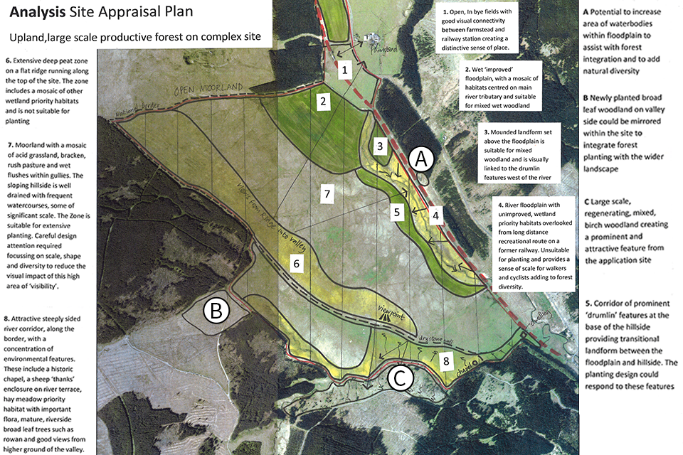
Map 2 (site appraisal plan): annotated aerial photo of complex upland site with large scale productive forest. Areas have been marked as 1 to 8 and A to C with brief descriptions.
Map 2 area descriptions
Areas A to C:
Area A: potential to increase area of waterbodies within floodplain to assist with forest integration and to add natural diversity.
Area B: newly planted broad leaf woodland on valley side could be mirrored within the site to integrate forest planting with the wider landscape.
Area C: large scale, regenerating, mixed, birch woodland creating a prominent and attractive feature from the application site.
Areas 1 to 8:
Area 1: open, in bye fields with good visual connectivity between farmstead and railway station creating a distinctive sense of place.
Area 2: wet ‘improved’ floodplain, with a mosaic of habitats centred on main river tributary and suitable for mixed wet woodland.
Area 3: mounded landform set above the floodplain is suitable for mixed woodland and is visually linked to the drumlin features west of the river.
Area 4: river floodplain with unimproved wetland priority habitats overlooked from long distance recreational route on a former railway. Unsuitable for planting and provides a sense of scale for walkers and cyclists adding to forest diversity.
Area 5: corridor of prominent ‘drumlin’ features at the base of the hillside providing transitional landform between the floodplain and hillside. The planting design could respond to these features.
Area 6: extensive deep peat zone on a flat ridge running along the top of the site. The zone includes a mosaic of other wetland priority habitats and is not suitable for planting.
Area 7: moorland with a mosaic of acid grassland, bracken, rush pasture and wet flushes within gullies. The sloping hillside is well-drained with frequent watercourses, some of significant scale. The zone is suitable for extensive plating. Careful design attention is required focusing on scale, shape and diversity to reduce the visual impact of this high area of visibility.
Area 8: attractive steeply sided river corridor along the border, with a concentration of environmental features. These include a historic chapel, a sheep ‘thanks’ enclosure on river terrace and hay meadow priority.
Example site 1 - upland: design concept plan:
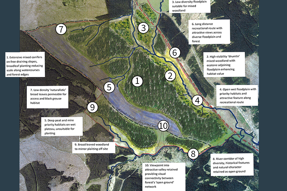
Map 2 (design concept plan): annotated aerial photo of complex upland site with large scale productive forest. Proposed design has been hand-drawn onto photo. Each design area is marked 1 to 10 with a description.
Upland: large scale productive forest on complex site.
Map 2 area descriptions
Area 1: extensive mixed conifers on free draining slopes, broadleaf planting reducing scale along watercourses and forest edges.
Area 2: high visibility ‘drumlin’ mixed woodland with ecotone adjoining floodplain enhancing habitat value.
Area 3: low diversity floodplain suitable for mixed woodland.
Area 4: open wet floodplain with priority habitats and attractive feature along recreational route.
Area 5: deep peat and mire priority habitats on wet plateau, unsuitable for planting.
Area 6: long distance recreational route with attractive views across diverse floodplain and forest.
Area 7: low density ‘naturalistic’ broad leaves permeable for access and black grouse habitat.
Area 8: river corridor of high diversity, historical features and natural character retained as open ground.
Area 9: broad leaved woodland to mirror planting off site.
Area 10: viewpoint into attractive valley retained providing visual connectivity between forest’s ‘open ground’ network.
Example Site 2: lowland
Landscape context plan:
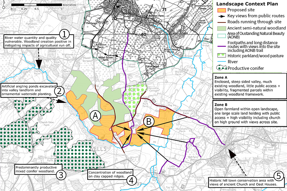
Map 3: annotated map showing the landscape context plan. The proposed site has been shaded orange. Areas have been marked as 1 to 5 with descriptions. Two zones have been marked as A and B with a description.
Map 3 area descriptions
Zone A: enclosed, steep sided valley, much existing woodland, little public access and visibility, fragmented parcels within existing woodland framework.
Zone B: open farmland within open landscape, one large scale land holding with public access and high visibility including church on high ground with views across the site.
Area 1: river water quality and quantity vulnerable. Woodland creation positive in migrating impacts of agricultural run off.
Area 2: artificial angling ponds excavated into valley landform and ornamental waterside planting.
Area 3: predominantly productive mixed conifer woodland.
Area 4: concentration of woodland on clay capped ridges.
Area 5: historic hill town conservation area with views of ancient church and oast houses.
Example site 2: lowland (zone A)
Site appraisal plan and design concept plan:
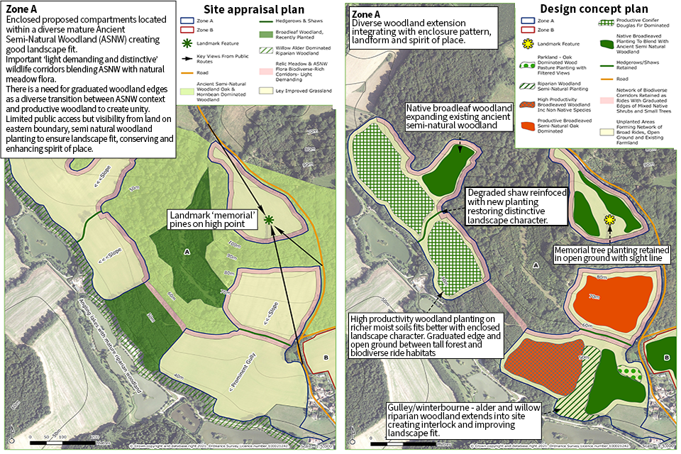
Map 4 and 5: annotated aerial photographs: site appraisal plan has areas labelled, such as slopes, a gulley and a landmark. The design concept plan shows the same areas but with proposed designs. A 'key' has been provided to show the different types of woodland etc. Areas are marked with brief descriptions.
Site appraisal plan text
Zone A: Enclosed proposed compartments located within a diverse mature Ancient Semi-Natural Woodland (ASNW) creating good landscape fit. Important ‘light demanding and distinctive’ wildlife corridors blending ASNW with natural meadow flora. There is a need for graduated woodland edges as a diverse transition between ASNW context and productive woodland to create unity. Limited public access but visibility from land on eastern boundary, semi natural woodland planting to ensure landscape fit, conserving and enhancing spirit of place.
Landmark: ‘memorial’ pines on high point.
Design concept plan text
Zone A: diverse woodland extension integrating with enclosure pattern, landform and spirit of place.
Broadleaf area: native broadleaf woodland expanding existing ancient semi-natural woodland.
Conifer and hedgerow/shaw area: degraded shaw reinforced with new planting restoring distinctive landscape character.
Memorial: tree planting retained in open ground with sight line.
Riparian woodland area: high productivity woodland planting on richer moist soils fits better with enclosed landscape character. Graduated edge and open ground between tall forest and biodiverse ride habitats.
Lower riparian area: gulley/winterbourne - alder and willow riparian woodland extends into site creating interlock and improving landscape fit.
Example site 2: lowland (zone B)
Site appraisal plan
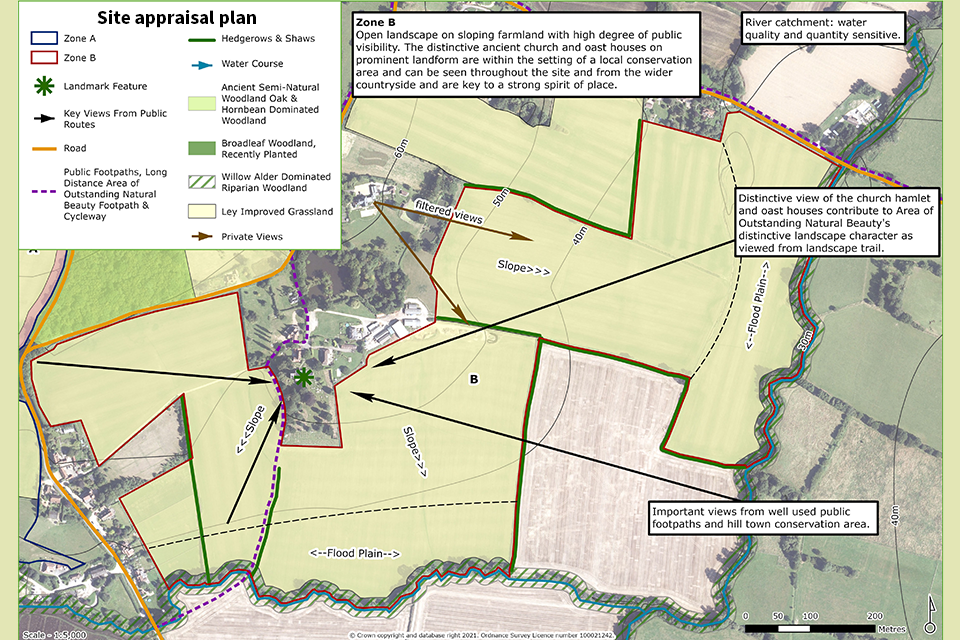
Map 6: aerial photograph with areas labelled, such as slopes, filtered views, floodplain. The map has been annotated to show area boundaries as well as brief descriptions of areas.
Site appraisal plan text
Zone B: open landscape on sloping farmland with high degree of public visibility. The distinctive ancient church and oast houses on prominent landform are within the setting of a local conservational area and can be seen throughout the site and from the wider countryside and are key to a strong spirit of place.
River catchment: quality and quantity sensitive.
Eastern viewpoint: distinctive view of church hamlet and oast houses contribute to Area of Outstanding Natural Beauty’s distinctive landscape character as viewed from landscape trail.
South eastern viewpoint: important views from well used public footpaths and hill town conservation area.
Design concept plan:
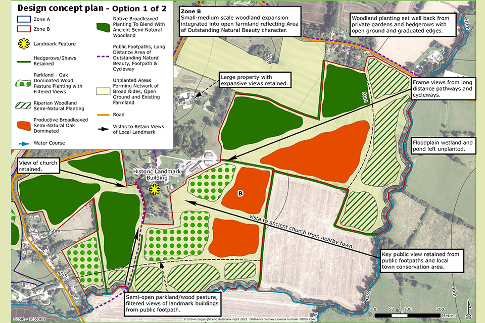
Map 6: annotated aerial photograph. A key shows colours and patterns for marked up areas. Planned designs have brief descriptions.
Design concept plan text
Zone B: small-medium scale woodland expansion integrated into open farmland reflecting Area of Outstanding Natural Beauty character.
Woodland: planting set well back from private gardens and hedgerows with open ground and graduated edges.
Eastern viewpoint: frame views from long distance pathways and cycleways.
Floodplain: wetland and pond left unplanted.
Public viewpoint: view retained from public footpaths and local town conservation area.
Parkland: semi-open parkland/wood pasture, filtered views of landmark buildings from public footpath.
View of church retained.
Appendix 2: visual outputs
Examples of visual outputs to accompany your maps and plans
Annotated photograph to accompany landscape context plan:
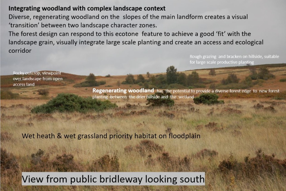
Image 1: annotated photo example of a complex landscape with various areas marked out such as floodplain, bracken, woodland and rocky areas.
Image 1 text
Integrating woodland with complex landscape content:
Regenerating woodland on the slopes of the main landform creates a visual transition between 2 landscape character zones. The forest design can respond to this ecotone feature to achieve a good fit with the landscape grain, visually integrate large scale planting and create an access and ecological corridor.
High area: rocky outcrop, viewpoint over landscape from open access land.
Mid area: rough grazing and bracken on hillside, suitable for large scale productive planting.
Woodland area: has the potential to provide a diverse forest edge to new forest planting between the drier hillside and the wetland.
Low area: wet heath and wet grassland priority habitat on floodplain.
Perspective analysis that zones the site from a key viewpoint, to accompany a site appraisal plan:
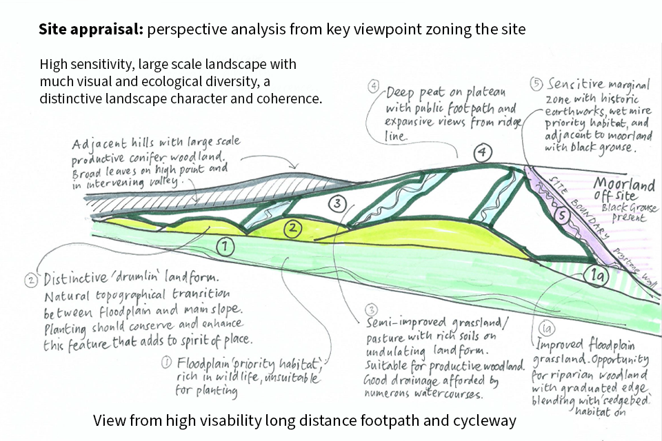
Image 2: a hand-drawn landscape: a long distance view from a footpath and cycleway. The drawing has been annotated with 5 areas marked 1 to 5.
Image 2 text
Site appraisal: perspective analysis from key viewpoint zoning the site.
High sensitivity, large scale landscape with much visual and ecological diversity, a distinctive landscape character and coherence.
Area 1: floodplain ‘priority habitat’ rich in wildlife, unsuitable for planting.
Area 2: distinctive ‘drumlin’ landform. Natural topographical transition between floodplain and main slope. Planting should conserve and enhance this feature that adds to spirit of place.
Area 3: semi-improved grassland/pasture with rich soils on undulating landform. Suitable for productive woodland. Good drainage afforded by numerous watercourses.
Area 4: deep peat on plateau with public footpath and expansive views from ridge line.
Area 5: sensitive marginal zone with historic earthworks, wet mire, priority habitat and adjacent to moorland with black grouse.
Annotated photograph to accompany site appraisal plan:
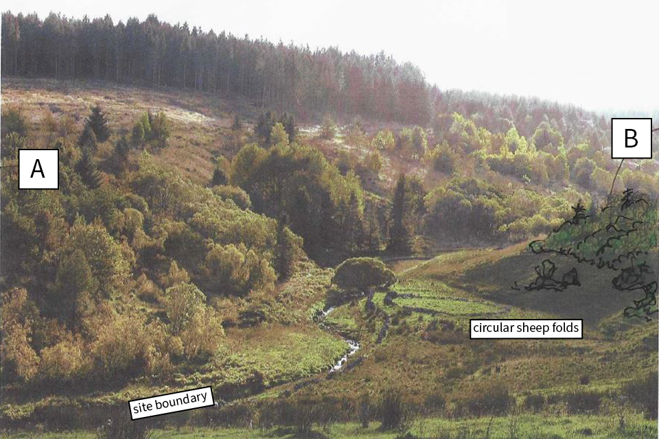
Image 3: annotated photograph to accompany a site appraisal plan: view of river corridor from open access land with conifer forest area on higher land. Upland, large scale productive forest on complex site. The river acts as site boundary. The flat lowland includes a circular sheep fold. Two areas have been marked as A and B.
Image 3 text
Carefully designed and sited ‘open’ planting fringing this corridor will extend and buffer the semi-natural character and provide a rich forest ecotone. Such an approach will deliver multi-beneficial objectives, forest resilience and enhance visual quality and integration.
Areas of open ground and more permeable, lower density broadleaf planting ensure good connectivity throughout the forest and add to multi-functionality and overall forest resilience.
Attractive river valley and habitat mosaic is left unplanted within an ‘open ground’ corridor, providing these benefits:
- protects the best historic and landscape features within the forest design
- provides an ‘open space’ network for access and biodiversity
- provides some migration for the loss of CROW open access land
Area A: regenerating birch-dominated mixed woodland adjoining site forms an important view from the elevated ridge running across the application site.
Area B: low density, naturalistic broad leafed planting mimicking regenerating woodland outside the site can be established at the top of sloping valley side. This approach assists in the new integration of the new scheme into the existing landscape.
Section showing integration of new woodland with landscape character:
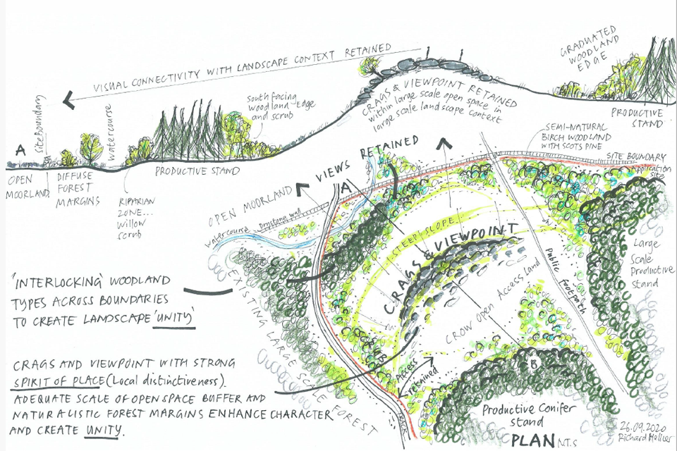
Image 4: an example of new woodland with landscape character. A hand-drawn map of the area showing how the proposed woodland will fill boundary areas.
Image 4 text:
Visual connectivity with context retained.
Interlocking woodland types across boundaries to create landscape unity.
Crags and viewpoint with strong spirit of place (local distinctiveness). Adequate scale of open space buffer and naturalistic forest margins enhance character and create unity.
3D perspective to accompany design concept plan:
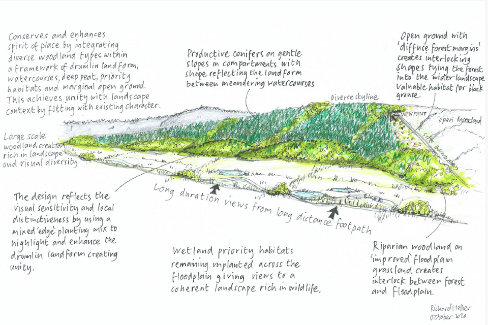
Image 5: 3D perspective to accompany design concept plan: hand-drawn image with hand-written text showing large scale woodland creation rich in landscape and visual diversity.
Image 5 text:
Conserves and enhances spirit of place by integrating diverse woodland types within a framework of drumlin landform watercourses, deep peat, priority habitats and marginal open ground. This achieves unity with landscape context by fitting with existing character.
Productive conifers on gentle slopes in compartments with shape reflecting the landform between meandering watercourses.
Open ground with ‘diffuse forest margins’ create interlocking shapes tying the forest into the wider landscape: valuable habitat for black grouse.
Wetland priority habitats remaining unplanted across he floodplain giving views to a coherent landscape rich in wildlife.
Riparian woodland on ‘improved’ floodplain grassland creates interlock between forest and floodplain.
3D perspective to accompany design concept plan:
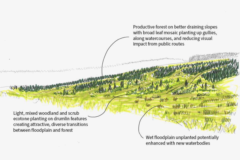
Image 6: 3D perspective to accompany a design concept plan: a hand-drawn view from public route showing planting design on lowlands and uplands.
Image 6 text:
High area: productive forest on better draining slopes with broad leaf mosaic planting up gullies, along watercourses, and reducing visual impact from public routes.
Middle area: light, mixed woodland and scrub ecotone planting on drumlin features creating attractive, diverse transitions between floodplain and forest.
Lower area: wet floodplain unplanted potentially enhanced with new waterbodies.
Annotated photograph to accompany design concept plans:
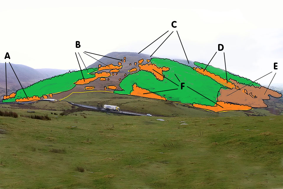
Image 7: annotated photograph example: a raised landscape with areas marked out as A, B, C etc.
Image 7 text:
Area A: create robust broadleaf coupes as permanent edge features.
Area B: expand planting onto open ground with broadleaf and conifer providing a link to both sides of the hill. Open access ensures a permanent open corridor with groups of broadleaves occasionally placed either side.
Area C: removal of tree cover areas from the skyline in particular locations. This will help balance the upper planting line and open the ridge feature and provide unimpeded views from the ridge itself.
Area D: create robust broadleaf riparian features as future coupe boundaries. These will be permanent landscape features with open crowned broadleaves and open space interlinked.
Area E: long-term retention of larch and pine. This will provide some temporary/permanent cover on the hillside to allow the redesign and re-establishment of the next rotation.
Area F: expand planting area where landform and design allows to create more productive elements and robust broadleaf features, which will act as permanent open crowned features.
Annotated photograph to accompany design concept plans:
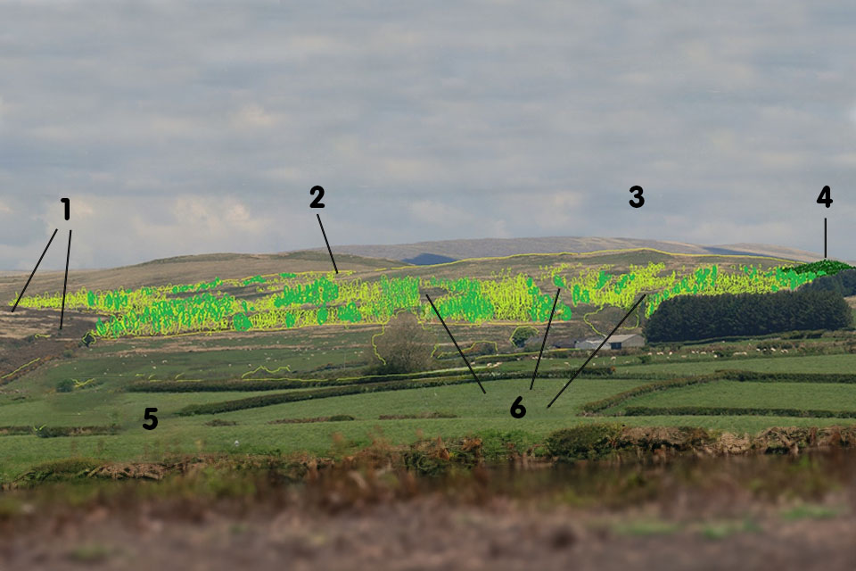
Image 8: annotated photograph example: a varied landscape with hand-drawn diagrams showing where woodland is to be planted. Areas are numbered 1 to 6.
Image 8 text:
Area 1: significant areas of open fell gorse thickets, will help merge forest and fell edges.
Area 2: the rising shoulder to the east will have tapering broadleaf species reaching towards the high point, accentuating the landform.
Area 3: the ridge will remain visible throughout the life of the plantation.
Area 4: conifer will come over the shoulder from the south face on drier soils and grassland, providing a merged conifer edge.
Area 5: native broadleaf species choice will use landform and vegetation to provide distinct areas of colour and texture to the face, providing diversity.
Area 6: visual, wildlife and vegetation links will be maintained between ridge top and valley below.
Appendix 3: issues log
An example issues log is given below, showing the types of issues it should cover.
| Issue (include date and raised by) | Applicant’s comments | Forestry Commission comments | Significance of impact (high, medium, low) | Status (open, closed) | Agreed mitigation |
|---|---|---|---|---|---|
| Example: Archaeology Scheduled Monument at NZ123456. Historic England, 23/10/16 | Example: scheme design includes open ground to buffer Scheduled Monument as per UKFS. John Smith, 25/10/16 | Example: applicant has taken on board Historic England feedback and designed the scheme in accordance with best practice. Susan Jones, 27/10/17 | Example: low | Example: closed | Example: 20 metre open ground buffer around Scheduled Monument |
| People | (example) | (example) | (example) | (example) | (example) |
| Historic Environment | (example) | (example) | (example) | (example) | (example) |
| Soil | (example) | (example) | (example) | (example) | (example) |
| Biodiversity | (example) | (example) | (example) | (example) | (example) |
| Landscape | (example) | (example) | (example) | (example) | (example) |
| Climate | (example) | (example) | (example) | (example) | (example) |
| Water | (example) | (example) | (example) | (example) | (example) |
| Material assets | (example) | (example) | (example) | (example) | (example) |
| Land use | (example) | (example) | (example) | (example) | (example) |
| Other | (example) | (example) | (example) | (example) | (example) |
Appendix 4: surveys
The following directory identifies the information type and some main sources of that information that should be investigated before undertaking on-site surveys. See Appendix 5 for more detail on sources of data and other information.
Information class: legal
Information required:
- ownership boundaries
- legal access points/routes
- other rights (for example, sporting)
- existing commitments such as agri-environment grant agreements
Data sources:
- property records (for example, deeds, leases and licences)
- RPA Online, MAGIC Map, or Forestry Commission Land Information Search
Information class: biodiversity
Information required:
- RAMSAR sites, Special Protection Areas (SPAs), Special Areas of Conservation (SACs), Sites of Special Scientific Interest (SSSIs), National Nature Reserves (NNRs), Local Nature Reserves (LNRs)
- Local Wildlife Sites (LWS), for example, Site of Nature Conservation Interest (SNCIs), Sites of Important Nature Conservation (SINCs), County Wildlife Sites (CWS) etc.
- priority habitats
- priority species
- existing agri-environment schemes and species targeting layers
- Important Bird Areas (IBAs)
- Important Plant Areas (IPAs)
- Forestry Commission/British Trust for Ornithology (BTO) wader sensitivity mapping and Botanical Society of Britain & Ireland/NE botanical heat maps
Data sources:
- MAGIC Map and Forestry Commission Land Information Search to identify presence or proximity of features. Engagement with Natural England to discuss planting opportunities and mitigation.
- MAGIC Map; engagement with local authorities and wildlife trusts
- MAGIC Map
- phase 2 habitat survey
- species survey
- Local Environmental Records Centre (LERC)
- consultant ecologist, where appropriate
- Biological Records Centre
- NBN Atlas
- previous grant applications on the land
Information class: landscape and visual
Information required:
- Landscape Character Area (refer to National Character Area profile).
Landscape Character Assessment: you should undertake a landscape survey, expressed in the form of a spatial plan and including or supported by the following information:
- visual context, including photographs
- visual detractors
- landscape designations
- viewpoints from within and outside planned woodland
- elements of landscape and visual diversity
- watercourses, infrastructure supply catchments
Data sources:
- National Character Area profile
- National Park, Community Forest, etc. - where relevant
- Area of Outstanding Natural Beauty
- local authority
- Landscape Architect, where appropriate
Information class: historic environment
Information required (designated heritage assets):
- World Heritage Sites
- Scheduled Monuments
- Listed Buildings
- Conservation Areas
- Registered Parks and Gardens
- Registered Battlefields
- advice on designated heritage assets and their settings
Information required (non-designated heritage assets):
- advice on non-designated historic features and HLC
- non-designated historic features
- Historic Landscape Characterisation (HLC)
- historic features visible in lidar data
- historic features visible on aerial and satellite images
- historic features visible on historic maps
Data sources:
- MAGIC Map
- National Heritage List (does not include World Heritage Sites)
- local authority planning or building conservation department (Conservation Areas only)
- Historic England local team
- local authority historic environment/ archaeology service
- local Historic Environment Record
- National HLC: Magic website
- Local HLC: local Historic Environment Record and/or Archaeology Data Service
- Environment Agency lidar data
- historic map webpages
- Google Earth
Information class: water
Information required:
- flood risk
- water quality
- surface water acidification
- water availability
Data sources:
- Environment Agency (main river) or Lead Local Flood Authority (if not a main river)
- Forestry Commission Land Information Search
- water provider
Information class: soil, species selection and silviculture
Information required:
- soil type and site conditions
- presence of peaty soils and deep peat on site
Data sources:
- Forest Research decision support system - Ecological Site Classification (ESC): Baseline, 2050 and 2080 ‘high’ scenarios
- site soil survey
- Natural England peat map and peat survey
Information class: people
Information required:
- existing Public Rights of Way
- CROW land
- common land
Data sources:
- MAGIC Map and Forestry Commission Land Information Search
- Local Access Forum
Appendix 5: references and additional sources of information
The following guidance and data sources will help you prepare a woodland creation design plan. Further information on each can be found by following the relevant links.
If you have difficulty accessing the links please try an independent internet search or contact your local Forestry Commission office for advice. When accessing external data you should always check the copyright details for how you can use the information.
UK Forestry Standard (UKFS)
UKFS acts as the foundation for sustainable forestry in all parts of the UK. The UKFS is agreed by all of the governments within the UK and links international obligations on sustainable forest management with policies on implementation. It therefore sets the context for forestry policy and practice in England.
Design techniques for forest management planning
The Forestry Commission practice guide, Design techniques for forest management planning, provides a step-by-step approach to design techniques used in forest management planning process. The guidance can be applied to both woodland creation and woodland management, and provides further information to supplement this guide.
Principles for afforestation on or near priority habitats
The Forestry Commission Operations Note 43: Principles for afforestation on or near priority habitats offers clarity on the principles to adopt when considering or planning woodland creation on or near priority habitats, including peat in England.
Priority open habitats and woodland creation: a field guide
Supplementary guidance offering an overview of those priority open habitats most likely to need consideration during the planning and assessment of woodland creation proposals.
Natural environment survey and assessment instructions
Find out how to assess whether your site might be suitable for woodland creation by carrying out species, peat and vegetation surveys.
Decision making framework for woodland establishment on peaty soils
A decision support framework for peatland protection, the establishment of new woodland and re-establishment of existing woodland on peatland has been developed to determine whether woodland establishment is appropriate on peaty soils.
The framework will be applied to proposals where any part of the site coincides with the Natural England peat map (including deep peat, shallow peat and other soils with peaty pockets categories) or as directed by your woodland officer. The peat map can be viewed on the Forestry Commission map browser and Land Information Search.
Guidance for afforestation proposed on or near nationally important upland breeding wader areas
This guidance note on upland breeding wader surveys has been jointly produced by the Forestry Commission and Natural England to help ensure that proposals for afforestation identify and avoid important breeding wader sites, for example, those sites that are capable of supporting breeding waders and where breeding waders are present. The note concentrates on species (curlew, lapwing, redshank, oystercatcher, snipe and golden plover) associated with upland farmland and moorland.
Forestry Commission Land Information Search
The Forestry Commission Land Information Search (LIS) is an interactive map browser that provides free access to Forestry Commission datasets covering land in England.
MAGIC Map application and local wildlife search
The Defra MAGIC Map application is another interactive map browser that provides free access to datasets. Magic provides details relating to, for example, priority habitats, priority species, designated areas and sites, current agri-environment schemes in place, and open access land. MAGIC allows users to run a constraints check against proposal areas and create a report.
NBN Atlas shows a map of species recorded, and other data, in the area identified for search.
Landscape Character Assessment (LCA)
Landscape Character Assessment (LCA) is an approach to understanding the differences between landscapes, and can serve as a framework for decision making that respects local distinctiveness. Specifically with respect to woodland schemes it will help to understand landscape context as part of the Landscape Character Appraisal that may be a condition of grant with the required outputs: landscape context, site appraisal and woodland design concept plans.
These are often prepared by local authorities and can usually be found through a basic internet search (there is no online central collection of LCAs for all of England). A new database of landscape character assessments is available from the Landscape Institute.
Review the relevant LCA for your proposal area and read the general sections of the report that apply to the entire LCA area; these will provide you with essential background and contextual information for your landscape. Review and consider the landscape character type, landscape description, forces for change and associated guidance; there are usually relevant sections on forest and woodlands. Use this information during the process of designing your new woodland, specifically when developing the landscape character appraisal for your proposal.
Read the guidance on preparing an LCA. Forestry Services have produced bespoke guidance relating to woodland creation schemes that ensures that proposals are compliant with UKFS.
National Character Area (NCA) profiles
England is divided: by natural lines in the landscape, rather than by administrative boundaries, into 159 distinct National Character Areas (NCAs), each defined by a unique combination of landscape, biodiversity, geodiversity, history, and cultural and economic activity. Each NCA has a profile that provides data, landscape descriptions and statements of environmental opportunity, which should inform woodland creation planning. Natural England hosts an online list of all NCA profiles.
Advice on tree pests and diseases
The tree pests and diseases collection gathers information on tree pests and diseases, including biosecurity, from the Forestry Commission and Animal and Plant Health Agency.
Ecological site classification (ESC)
The Ecological Site Classification Decision Support System can help you to choose appropriate tree species to match the site. ESC is designed to match key site factors (soils, rainfall, land drainage etc.) with the ecological requirements of different tree species and woodland communities. It can also be used to predict climate suitability for tree species in 2050 and 2080.There are default settings but inputting site specific data, for example soil moisture and nutrient status, will significantly improve your results.
Environmental Impact Assessment
Read our guidance on EIA for woodland creation.
Natural colonisation
If you plan to create your new woodland via natural colonisation, read natural colonisation for the creation of new woodland.
Historic environment
Information on designated heritage assets, including World Heritage Sites, Scheduled Monuments, Listed Buildings, Registered Parks and Gardens, and Registered Battlefields, can be found on the Defra MAGIC Map application and the National Heritage List. It may be necessary to contact local authority planning or building conservation departments and use their websites to identify conservation areas.
Where your site includes (or has in a close proximity) a World Heritage Site, Scheduled Monument, Registered Battlefield, Grade I or II Listed Building or Grade I or II Registered Park and Garden you will need to contact the relevant Historic England local team. If your site includes (or has in close proximity) a Grade II Listed Building or Grade II Registered Park and Garden you may need to contact Historic England’s local team your Woodland Officer can provide guidance on this. If your site is within or close to a World Heritage Site it would be advisable to contact the appropriate partnership board. If it is within a Registered Park and Garden it would be advisable to seek the views of the local Gardens Trust.
Local authority historic environment/archaeology services must be contacted to request any historic environment records and to seek advice on non-designated assets, including how they can be considered in woodland creation proposals. They should be asked to check the local Historic Environment Record (HER), local Historic Landscape Character (HLC) data, lidar data, aerial/satellite images and historic maps for you. Contact details for local authority historic environment/archaeology services can be found at Association of Local Government Archaeological Officers (ALGAO54).
There may be a charge for local authority historic environment/archaeology service advice in some areas.
Information on non-designated historic features can be obtained from a range of sources, including the local HER, lidar data and historic maps. Local authority historic environment/archaeology services will check their HER for you, but further details can be found on the Heritage Gateway (although this website holds records on some heritage assets, it and other online heritage datasets are often incomplete and therefore must not be relied upon to inform woodland creation). Selected historic maps are available in local Record Offices and online, including on the National Library of Scotland’s map images website and Old-Maps Environment Agency lidar images can also be viewed on the National Library of Scotland website and on Flickr aerial and satellite images.
National Historic Landscape Characterisation (HLC) data is available through the ‘Landscape – Landscape Classifications section of the MAGIC Map Application. Some Historic Environment Records hold local HLC data. Selected local HLC data is held by the Archaeology Data Service.
Information on water quality, flood risk and other water related issues
In addition to information found on our Land Information Search (LIS), and MAGIC, the following are useful:
- Environment Agency contact details
- flood risk map
- long term flood risk for an area in England
- main rivers consultation
- data on water abstraction licenses: [email protected]
- groundwater source protection data and aquifer designations can be found on MAGIC
Local Environmental Records Centres (LERCs)
The Association of Local Environmental Records Centres is a membership organisation representing LERCs across the United Kingdom. It promotes the standing of LERCs as the definitive source of high quality, local, capture-resolution biodiversity data to inform the decision-making process, provides representation at a national and regional level and seeks to enhance the professional standing of LERCs through its accreditation scheme. As a central hub of environmental information at the local level LERCs will be able to provide confirmation of the Local Wildlife Site (LWS) status of your land and information on the presence of protected and priority species.
Ordnance Survey maps
An Ordnance Survey (OS) map provides a lot of information about what exists within the local area, such as properties, rights of way, streams and rivers, ponds and reservoirs, and places of public interest. It has contours to help evaluate slopes in the landscape. Old maps may also be useful.
It is a good idea to compare the OS map of your site and its surrounding area against recent aerial photography to check that features (hedgerows, woodland boundaries, ponds and other identified features) align with reality. Different websites often hold aerial photographs of different ages, which allows for historic comparison if necessary.
Forestry Commission consultation and public registers
Read guidance on how to access and use Forestry Commission’s public registers.
